Severe Weather Warnings
Types of weather covered
We provide Severe Weather Warnings for potentially hazardous or dangerous weather that is not solely related to severe thunderstorms, tropical cyclones or bushfires.
Damaging winds
Severe Weather Warnings are issued for damaging winds, including:
- sustained gale force winds – 63 km/h or more
- damaging wind gusts – 90 km/h or more, except in Tasmania and the NSW alps.
In Tasmania, we issue damaging wind warnings for gusts of 80 km/h or more in easterlies, and 100 km/h or more in westerlies.
For the NSW alps above 1,900 m, we issue damaging wind warnings for gusts of 125 km/h or more, or average wind speeds of 80 km/h or more.
Destructive winds
Severe Weather Warnings are issued for destructive winds, including:
- gusts of 125 km/h or more, except in Tasmania where we issue these warnings for easterly wind gusts of 110 km/h or more
- average wind speeds of 89 km/h or more.
Rain and blizzards
We also issue Severe Weather Warnings for:
- heavy or intense rain that may lead to flash flooding
- blizzards in alpine areas. Warnings for blizzards are only issued with a damaging wind warning.
When do we issue Severe Weather Warnings?
These warnings are issued whenever severe weather is:
- happening in an area, or
- expected to develop or move into an area.
The lead time depends on the weather situation. It can extend from an hour to 36 hours.
What's included
A Severe Weather Warning includes:
- a list of all potential phenomena, forecast districts and locations that may be affected
- a description of the threat and the area likely to be affected (the threat area)
- the time the warning was issued and what time the next warning will be issued
- a description of the weather pattern, including forecast developments of significant weather systems
- a technical summary of all potential phenomena, their timing and likelihood
- confirmed observations and reports
- recommended actions.
Updates
While the threat remains, a Severe Weather Warning is updated routinely every 6 hours. More frequent warnings may be issued if required.
Limitations
Warning services may be more limited for remote and unpopulated areas. This is because data may not be available for effective monitoring and prediction.
Coastal Hazard Warnings
Types of weather covered
We warn about hazards that involve sea level or surf affecting Australia's coast. We provide Coastal Hazard Warnings for:
- abnormally high tides
- damaging surf.
Abnormally high tides
We issue warnings for sea levels that:
- may be higher than the highest astronomical tide, and
- could flood low-lying coastal areas.
Learn more about tides and sea level.
Damaging surf
We issue warnings when unusually large surf may damage beaches and coastal infrastructure.
When do we issue Coastal Hazard Warnings?
These warnings are issued whenever a coastal hazard is:
- happening in an area, or
- expected to develop or move into an area.
The lead time depends on the weather situation. It can extend from an hour to 36 hours.
What's included
A Coastal Hazard Warning includes:
- a list of all potential phenomena, coastal forecast districts and locations that may be affected
- a description of the threat and the area likely to be affected (the threat area)
- the time the warning was issued and what time the next warning will be issued
- a description of the weather pattern, including forecast developments of significant weather systems
- a technical summary of all potential phenomena, their timing and likelihood
- confirmed observations and reports
- recommended actions.
Updates
While the threat remains, a Coastal Hazard Warning is updated routinely every 6 hours. More frequent warnings may be issued if required.
Limitations
Warning services may be more limited for remote and unpopulated areas. This is because data may not be available for effective monitoring and prediction.
Severe Thunderstorm Warnings
Warning about thunderstorms
All thunderstorms are dangerous because they produce lightning.
In Australia, we don't warn about all thunderstorms – only those classified as severe or very dangerous.
Severe thunderstorms
Thunderstorms are classified as severe when they produce one or more of these phenomena:
- large hail – 2 cm in diameter or greater
- damaging wind gusts – 90 km/h or greater
- tornadoes
- heavy rainfall that may lead to flash flooding.
Very dangerous thunderstorms
Thunderstorms are classified as 'very dangerous' when they produce one or more of these severe phenomena:
- giant hail – 5 cm in diameter or greater
- destructive winds gusts – 125 km/h or greater
- tornadoes
- intense rainfall that may lead to dangerous and life-threatening flash flooding.
Learn more about thunderstorms.
When do we issue Severe Thunderstorm Warnings?
We issue a Severe Thunderstorm Warning when:
- a severe thunderstorm is occurring, likely to occur or is reported
- existing thunderstorms are likely to develop into a severe thunderstorm
- phenomena such as large hail, giant hail, damaging winds, heavy rainfall, intense rainfall or tornadoes are expected in the warning area.
Severe thunderstorms can be quite localised and can develop, evolve and dissipate quickly. The exact location can be hard to predict, even with short lead times.
Types of Severe Thunderstorm Warnings
We provide two types of Severe Thunderstorm Warning:
- Detailed Severe Thunderstorm Warning
- Regional Severe Thunderstorm Warning.
Detailed Severe Thunderstorm Warnings
We issue these warnings for all capital cities and surrounding areas. They are issued when individual severe thunderstorms are within range of the capital city radars.
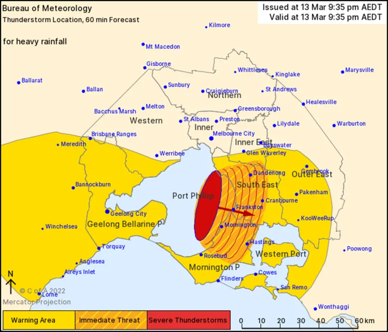
Detailed warnings provide time and location-specific information about the threat. The warning includes a map showing:
- any existing severe thunderstorms as a red ellipse
- the forecast direction of movement for up to 60 minutes, in red arrows
- the Immediate Threat Area, shaded with orange-hash.

Example of a detailed severe thunderstorm warning map
Regional Severe Thunderstorm Warnings
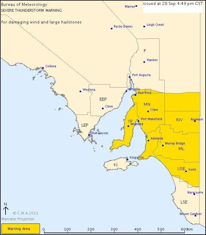
This type of warning is issued for all Australian states and mainland territories. They highlight broad areas where severe thunderstorms are occurring or may occur in the next 3 hours.
These warnings:
- are based on broad areas, such as our weather forecast districts
- include a map with the areas covered by the warning shaded in yellow.

Example of a regional severe thunderstorm warning map
What's in Severe Thunderstorm Warnings
Both types of Severe Thunderstorm Warning include:
- a list of all potential phenomena, warned forecast districts and locations which may be affected
- the time and date the warning was issued and what time the next warning will be issued
- a description of the weather pattern, sometimes including forecast developments of significant weather systems
- confirmed observations and reports
- recommended actions.
If appropriate, the warnings may ask media to use the Standard Emergency Warning Signal (SEWS) in Queensland, Victoria and Tasmania. This is only used for the most serious events, such as confirmed very dangerous thunderstorms.
Severe thunderstorms during other severe weather events
Severe thunderstorms can happen during a more widespread severe weather event. For example, a band of heavy rain or vigorous cold front.
We work out which warnings will best inform the public about the hazards. We take into account warnings already in place and may consult local emergency services agencies.
Staying safe in severe weather
Preparing for severe weather
- Check forecasts and warnings on this website or the BOM Weather app. Listen to your local radio station for warnings and updates.
- Shelter and secure pets and animals.
- Check your yard or balcony. Secure or store items that could blow around in strong winds – for example, garden furniture, trampolines.
- Park vehicles under solid shelter or cover with firmly tied tarpaulins or blankets.
- Secure all external doors and windows and draw curtains.
- Charge your mobile phone and other devices. Unplug these before the severe weather arrives.
- Put valuables, medications and spare warm clothing in plastic bags with your emergency kit and keep it handy.
When a thunderstorm strikes
- Stay inside and shelter well clear of windows, doors and skylights.
- Don't use a phone landline, as the wiring can carry electrical charges from lightning. This can mean deadly electric shocks or deafening sound blasts.
- Avoid touching brick or concrete, or standing bare-footed on concrete or tiled floors.
- Continue to check this website or the BOM Weather app. Listen to your local radio station for warnings and updates.
Don't:
- drive, walk, ride or swim through flood waters, or drive through water flowing over roads
- fly kites, drones or model aeroplanes with control wires
- handle fishing rods, umbrellas, golf clubs or similar items
- go near metal poles, fences, clotheslines or other metal structures
- ride horses, bicycles or travel in open vehicles.
If caught outdoors
- Seek shelter in a hard-top vehicle or solid building. Avoid small open structures or fabric tents.
- Never shelter under a tree or group of trees.
- If far from shelter, crouch (alone, feet together), preferably in a ditch or hollow. Remove metal objects from your head and body. Stay low – don't lie flat but avoid being the tallest object.
- Move immediately if your hair stands on end or you hear 'buzzing' from nearby rocks, fences or other objects. At night, a blue glow may show if an object is about to be struck (St. Elmo's fire).
On the water
If you're swimming or surfing, leave the water immediately.
If boating:
- go ashore to shelter as soon as possible
- make sure the mast and stays of a sailing boat are adequately 'grounded' to the water.
More information about severe weather safety
For more information to help you prepare, respond and recover, visit the National Emergency Management Agency.
Audio warnings
To get the latest warnings by phone at any time, call 1300 659 210.
Epidemic thunderstorm asthma
The Bureau doesn't issue thunderstorm asthma warnings. Check with your state or territory health authority to find out how alerts are issued for your local area. Their details are available on the Department of Health, Disability and Ageing website.
Epidemic thunderstorm asthma can happen during grass pollen season – October through December – in south-east Australia. It may be triggered by a unique combination of:
- high amounts of grass pollen in the air
- thunderstorms that produce wind gusts. Learn more about this thunderstorm phenomena.
You may be at increased risk if you have:
- current, past or undiagnosed asthma, and/or
- seasonal hay fever.
Resources
- Better Health Channel for more about thunderstorm asthma, who is at risk and how to protect yourself.
- Victorian Department of Health epidemic thunderstorm asthma program and risk forecasting system.
- Healthdirect website or Asthma Australia for information about thunderstorm asthma symptoms, prevention and treatment.
- Asthma first aid – Asthma Australia.
Service level specification for thunderstorms and severe weather
This document describes our public thunderstorm and severe weather services. It also outlines additional services we provide to support emergency management.