
Flood Warning Infrastructure Network (FWIN) Program
Australians rely on us to provide flood forecasts and warnings. We are improving this vital service through the National Flood Warning Infrastructure Network Program.
The Australian Government is investing up to $236 million for this national 10-year program. It enables the Bureau to acquire and upgrade flood infrastructure, including:
- high-priority rain and river gauges
- supporting communications equipment.
The focus is on critical catchments in each state and territory.
Video: Flood warning infrastructure network program
Currently, there are more than 8,000 rain and river level gauge sites across Australia and the Bureau owns about one third of these gauges that it relies on to deliver flood forecasts and warnings.
Over the next 10 years the Bureau will acquire, upgrade and maintain around 1,600 additional flood warning sites located in high priority catchments across the country.
The work will lead to a modernised and well-maintained network that will enhance flood forecasts and warnings and improve community preparedness for flooding.
The national Flood Warning Infrastructure Network Program, known as FWIN, began in Queensland, where around 1,000 gauges will be upgraded by June 2029. The 10-year program will reach all states and territories. Upgrades will take place in a staggered approach over several years.
FWIN's acquisition of rain and river level gauge sites across the country is scheduled to be completed by June 2033.
Funded by the Australian Government, ongoing maintenance will be shared between the Bureau and state governments and reduce the financial burden on local councils to maintain flood warning sites.
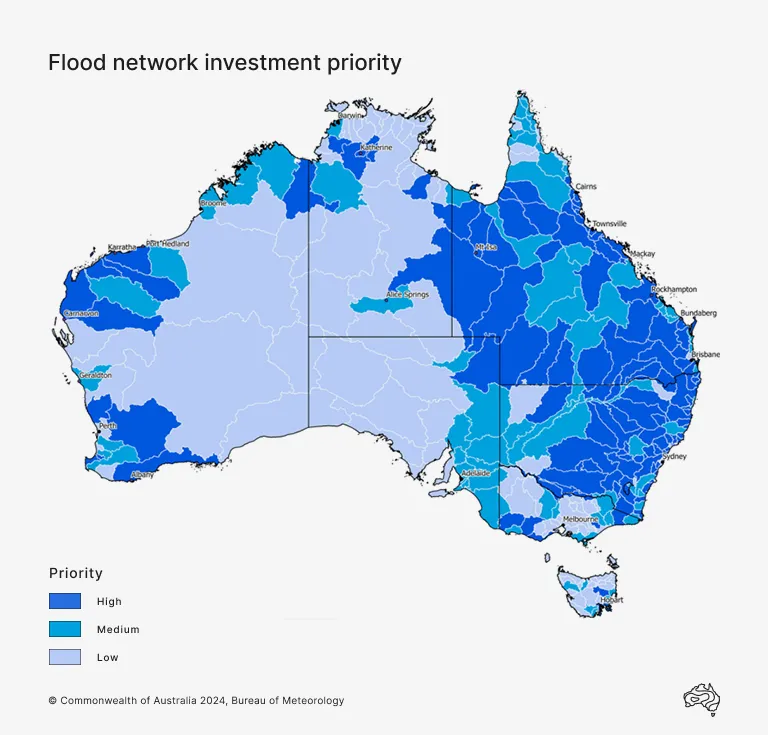

This is an initial map of priority catchments. We are working closely with state and territory government partners to confirm the prioritisation of catchments.
Schedule and progress
Details of the schedule and progress for each state and territory.
Schedule
Detailed planning: July 2023 to June 2024 – Completed.
Site acquisition and upgrade work: from July 2024 – In progress.
Site maintenance: from July 2025 – In progress.
The full Queensland program will include about 1,100 sites across 46 of the state's flood watch catchments.
Progress
As of October 2025:
2023–24
Detailed planning was carried out with state government partner Queensland Reconstruction Authority (QRA) and 62 local government asset owners.
2024–25
The Bureau and local councils agreed to acquire and, when required, upgrade about 900 flood assets over 5 years.
Detailed site assessments began to evaluate infrastructure condition and remediation needs.
Site acquisitions began, with 200 transfer of equipment agreements issued to local councils.
Remediation work began in Cairns in July 2024.
2025–26
Detailed site assessments continue.
Target of 370 acquisitions scheduled to occur by the end of the financial year.
Remediation work continues.
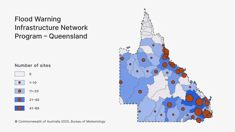

Sites in Queensland identified for acquisition
Queensland flood catchments under the FWIN program with number of sites agreed for acquisition
The number of sites can change. This list is current October 2025.
Balonne River, 18.
Barron River, 26.
Belyando and Suttor Rivers to Burdekin Falls Dam, 13.
Black River, 11.
Bulloo River (Qld), 8.
Burdekin River downstream of Burdekin Falls Dam, 21.
Burdekin River to Burdekin Falls Dam, 21.
Burnett River, 42.
Burrum and Cherwell Rivers, 17.
Cape River to Burdekin Falls Dam, 3.
Cloncurry River, 9.
Condamine River, 91.
Cooper Creek, 10.
Daintree River, 7.
Dawson and Don Rivers, 48.
Diamantina River, 17.
Don and Proserpine Rivers, 21.
Georgina River and Eyre Creek, 13.
Gilbert River, 1.
Haughton River, 16.
Herbert River, 30.
Johnstone River, 23.
Leichhardt River, 5.
Logan and Albert Rivers, 26.
Lower Brisbane River, 58.
Lower Flinders River, 8.
Macintyre River, 28.
Mackenzie and Fitzroy Rivers and Shoalwater and Water Park Creeks, 9.
Mary River, 30.
Mitchell River, 2.
Moonie River, 2.
Mossman River, 4.
Mulgrave and Russell Rivers, 15.
Murray River, 6.
Nicholson River, 14.
Norman River, 16.
Paroo River (Qld), 6.
Pioneer River, 25.
Ross and Bohle Rivers, 34.
Tully River, 12.
Upper Brisbane River, 10.
Upper Flinders River, 12.
Wallam and Mungallala Creeks, 7.
Warrego River (Qld), 27.
Weir River, 16.
Schedule
Detailed planning: July 2024 to June 2025 – Completed.
Site acquisition and upgrade work: July 2025 to June 2030 – In progress.
Site maintenance: from July 2026.
The full NSW/ACT program will include about 258 sites across 50 flood watch catchments.
Progress
As of October 2025:
2024–25
Detailed planning is progressing with the ACT government partner, Environment, Planning and Sustainable Development Directorate.
Detailed planning conducted with state government partner NSW Department of Climate Change, Energy, the Environment and Water (DCCEEW) and 26 local government asset owners.
The Bureau, NSW DCCEEW and local councils agreed on an initial list of about 140 flood assets to acquire and, where required, upgrade.
Detailed site assessments began to evaluate current infrastructure, its condition, and the level of remediation required.
2025–26
Thirty sites in the Northern Rivers region have been acquired with remediation to be carried out, where required, this financial year.
Detailed site assessments continue.

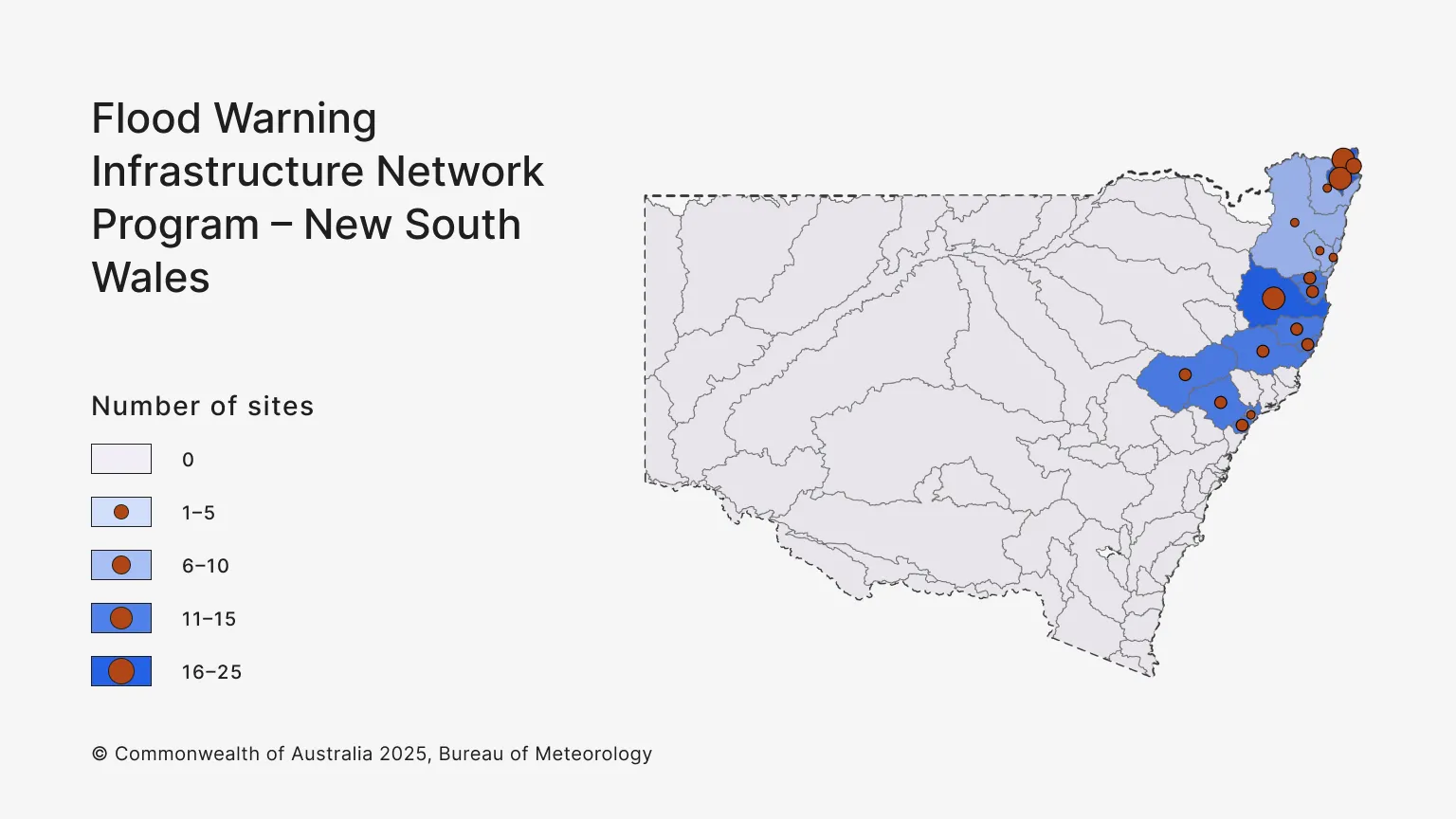
Sites in New South Wales identified for acquisition
NSW flood catchments under the FWIN program with number of sites agreed for acquisition
The number of sites can change. This list is current October 2025.
Bellinger and Kalang Rivers, 8.
Brunswick River and Marshalls Creek, 13.
Camden Haven River, 8.
Clarence River, 1.
Coffs Coast, 4.
Goulburn and Upper Hunter Rivers, 7.
Hastings River, 7.
Lake Macquarie, 10.
Macleay River, 18.
Manning and Gloucester Rivers, 6.
Nambucca River, 6.
Newcastle Area, 1.
Orara River, 1.
Richmond River, 3.
Tweed and Rouse Rivers, 23.
Wilsons River, 18.
Wollombi Brook and Lower Hunter River, 7.