
How bushfires make thunderstorms
Weather conditions can increase the risk of bushfires and make them harder to fight. But fires can also create conditions that lead to thunderstorms – pyrocumulonimbus clouds.
In Australia, these clouds most commonly form in large and intense bushfire smoke plumes. The official name for them is 'flammagenitus'. They are also called fire-generated thunderstorms.
Video: Pyrocumulonimbus at the Sedgerly Fire, Queensland
How pyrocumulonimbus clouds form
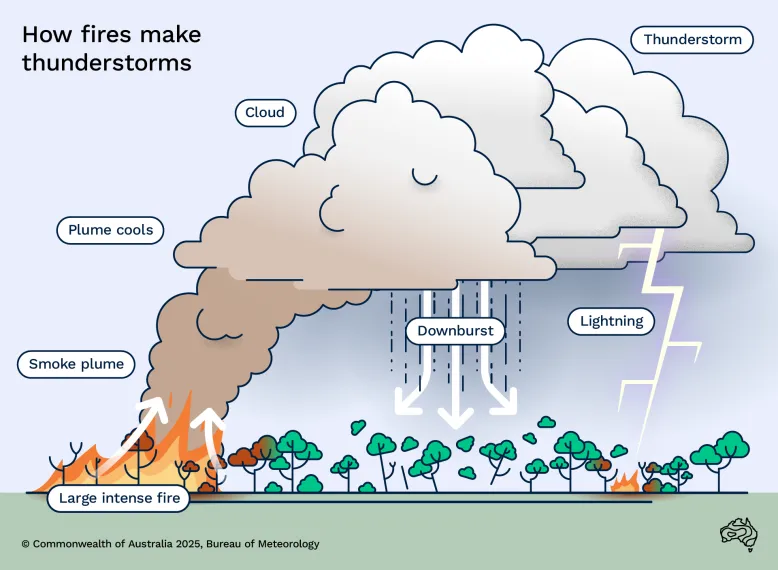
Intense heat from the fire makes air rise rapidly in the smoke plume. The rising hot air is turbulent and draws in cooler air from outside the plume. This helps cool the plume as it rises.
Cooling creates cloud
As the plume rises higher, the atmospheric pressure reduces. This makes the plume air expand and cool even more. If it cools enough, moisture in the plume air turns from a gas to liquid – it condenses. This creates cumulus cloud. Because the cloud comes from the fire (pyro) plume, we call it ‘pyrocumulus’.
Cloud rises
The condensation process releases heat. This makes the cloud warmer and more buoyant, driving air upwards. Further expansion and cooling means more condensation. The cloud air accelerates upwards even more. In the right conditions, it reaches the upper troposphere before losing buoyancy. The cloud is now a ‘pyrocumulonimbus’.
Lightning sparks
Different types of ice particles collide in the very cold upper parts of these clouds. This may build electrical charge, which is released by giant sparks – lightning. Sometimes lightning does not develop in pyrocumulonimbus clouds. This is due to smoke in the clouds changing how the ice forms.

Dangers of fire-generated thunderstorms
These thunderstorms can be linked to dangerous and erratic fire behaviour. This can make the fire more difficult and hazardous to fight.
Change in fire direction and intensity
When fire-generated thunderstorms form, there can often be intense updrafts in the smoke plume. An updraft is fast-moving wind that flows vertically upwards. Scientists are still investigating whether:
- a thunderstorm causes these plume updrafts to intensify, or
- intense plume updrafts make a fire-generated thunderstorm more likely to happen.
These powerful plume updrafts can draw in so much air that strong winds develop. The winds are drawn in from many directions towards the plume. This can cause:
- the fire to burn hotter and sometimes spread faster
- unexpected changes in the direction of nearby fires, including spot fires from embers and lighting strikes.
Spot fires
The updrafts become very tall and strong. They can carry large burning embers and lift them to great heights. The embers travel far downwind, where they can ignite new fires (spot fires). During Victoria’s Black Saturday bushfires in 2009, one spot fire was recorded more than 30 km from its parent fire.
Lightning
Lightning can form in fire-generated thunderstorms, which can cause new fires. In Victoria’s Black Saturday fires, lightning started a new fire 100 km from the fire front.
Downbursts
Thunderstorms can produce intense downbursts that hit the ground and burst outwards. This can produce very strong and gusty winds lasting 20 minutes or more. These winds can be strong enough to spread the fire in any direction.
Downbursts from thunderstorms near fires have been responsible for the deaths of firefighters, by blowing fire back toward them. Fire-generated thunderstorms could pose a similar threat.
Video: Weird Weather: Pyrocumulonimbus
I'm not a pyromaniac myself, even though I do like fire, but there are some clouds that are – and when they form they get such incredible powers that they can destroy everything in their path. Some of the most extreme bushfires that Australians have endured, like the Black Saturday fires or the Canberra fires, were made significantly worse by the weather that these fires created themselves.
In order to get clouds, you need to get air from the surface high up into the atmosphere. So when you have a bushfire it can heat the air around it and if conditions are just right it can rise up and form a type of cloud called a pyrocumulus.
Now, if conditions are perfect, if the fire's really intense, if the atmosphere is unstable that air can get really, really high, like super-high.
We're talking 1215 km or more, and on its way up to those great heights ice can form and you can get violent winds, and thunder and lightning.
It's all very very frightening. And when that happens the cloud evolves into a type of cloud called a pyrocumulonimbus.
We're essentially just talking about a thunderstorm here, but it's a thunderstorm with a terrifying fuel source at its fingertips.
And when this pyromaniac cloud really heats up, that's when it gets some terrifyingly destructive superpowers, like the ability to hurl burning embers up to 30 km away, or to strike lightning a hundred kilometres downstream from the fire front that can create even more bushfires. They've even been known to hurl down large black hailstones.
One of the most terrifying superpowers of these pyromaniac clouds can get is the ability to make tornadoes. Wait, no, actually scrap that, it's the fire tornado.
That's where you just get a tornado and fire, two of nature's most terrifying things, then just mash them together to get a tornado made of fire. One of the most destructive fire tornadoes we know about was during the 2003 Canberra fires.
Four lives were lost and more than 500 homes were destroyed, but residents knew that it wasn't just a bushfire. When they came home they found cars flipped and trees ripped out of the ground and thrown kilometres away.
Such a large area was alight during the fire and so much energy was released into the atmosphere that during the ten minutes of most intense flaming there was more energy released than during the explosion of the Hiroshima atomic bomb.
All of these superpowers mean that the pyromaniac clouds can create even more destruction and can create even more bushfires, and that means they have the ability to multiply.
They also create incredibly strong winds as gust fronts and updrafts and downbursts and that can make fire move in completely unpredictable ways.
That can put firefighters' and residents' lives in even more danger.
Unfortunately, it can be extremely difficult for the Bureau of Meteorology to forecast these pyro clouds and with the unpredictable way they move and and the complete destruction they can bring, it's best to just be as prepared as possible and get out of their way.
Just out
Move
Shoo
Like just out
Don't even think twice. If you're told to evacuate, move.
Predicting fire-generated thunderstorms
Studying how fire-generated thunderstorms develop helps us predict their formation, intensity and danger.
Using very high resolution computer models to make virtual smoke plumes, we study:
- how the plumes behave in different wind environments
- how far they can transport embers.
For example, plumes tend to become taller in lighter background winds than in stronger winds. In stronger winds, they tend to bend over and have little turrets of smoke off the top.
Calculating firepower
We use thermodynamic (heat and energy) equations. These help us understand how air coming into the plume affects the height at which cloud can form.
Using atmospheric temperature and moisture information from a radiosonde (weather balloon) or computer weather model, we determine how:
- high a smoke plume must rise before cloud will form
- buoyant the plume needs to be for deep cloud, which may become pyrocumulonimbus, to develop
- much heat (firepower) a fire must produce to generate a thunderstorm. Forecasting firepower – when and where it will be greatest – helps fire agencies respond to the threat.
Understanding how embers travel
We've also used these equations to develop a simple model to predict ember transport. This now part of fire spread models used by fire agencies.
Forecasting fire spread
We're using fire plume models and thermodynamic equations to build and improve tools that help predict fire behaviour. One of these is a fire–atmosphere model, which simulates how fires burn through the landscape. It helps us understand why some fires behave in unexpected ways. These models are regularly tested and improved.
Climate change and fire-generated thunderstorms
Research continues into how climate change influences conditions that cause these thunderstorms.
Climate models suggest conditions associated with fire-generated thunderstorms may become more dangerous in some regions, such as south-east Australia.
For more information about climate change and bushfire risk, view our How weather affects fires page.