
Sea levels are rising around Australia. This increases the risk of flooding and damage to coastal infrastructure and communities. Bureau researchers have developed new datasets and techniques to help manage today's extremes becoming tomorrow's high tide.
New datasets to inform coastal management
The researchers have developed 2 new datasets.
The first dataset shows the sea-level rise that will cause very rare events to become commonplace. It examines this for 37 key coastal settlements.
The second dataset shows the sea-level rise that will lead to normal tides causing flooding. It looks at coastal rivers and lakes across eastern Australia.
Current coastal flooding
Coastal flooding occurs when high tides and storm surges cause impacts such as flooding of streets, paths and property. It's more frequent on the east coast, where high tides can cause flooding even without severe weather.
Flooding is classified based on its severity.
- Minor flooding causes inconvenience and closures of minor roads.
- Moderate flooding impacts buildings and main traffic routes.
- Major flooding isolates properties and towns, likely closing major traffic routes.
Minor flooding happens less than once every 5 years at each location researchers studied. Moderate and major floods are even rarer, with most locations not having a major flood in the last 20 years.
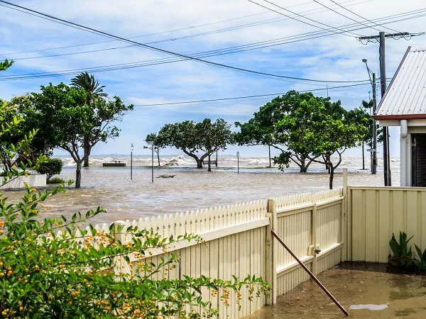
Coastal flooding in Sandgate, Brisbane, Queensland
Future coastal flooding
The new datasets can help scientists predict how much more often coastal floods seen in the past will occur with future sea-level rise.
Analysis of both datasets shows that a sea-level rise of 35 cm is enough for a rare coastal flood to occur 100 times more often than in the current climate. Latest projections show that sea-level rise is expected to reach 35 cm in about 50 years.
In the next 25 years, floods will happen 10 times more often than they do now. State and local governments are planning for sea-level rises of up to 1 m by 2100. This is enough for a 3000-fold increase in how often sea levels rarely seen today will occur at 85% of the coastal settlements in the study.
Most states and territories are planning for between 80 cm and 1 m of sea-level rise before 2100. This means that minor flood levels will be exceeded by tides alone at 40% of the locations studied by the end of the century.
Several locations expect major flood levels to be exceeded by tides alone under 70 cm sea-level rise. The locations include Lakes Entrance (Victoria), Mooloolaba (Queensland) and Stockton (New South Wales). Once tidal flooding starts, it doesn't take much more sea-level rise for it to occur very often. An average of 4 cm sea-level rise is enough for annual tidal flooding to occur after the first instance, and only 11 cm more for it to happen monthly.
Without effective action, these events will become chronic hazards at most locations with less than 1 m sea-level rise. Mooloolaba is particularly at risk, with 31 cm sea-level rise enough for moderate flooding to occur monthly.
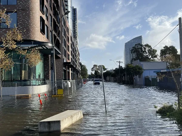
Inundation of streets and paths in Southbank, Melbourne – a typical impact of coastal flooding. Credit: Ben Hague
Improving coastal decision-making
Climate adaptation involves changing our environment, society or economy to respond to changes in weather and climate impacts. At the coast, hazards like flooding and erosion require adaptation. State and local governments have identified actions, including:
- avoid building new assets in hazard areas
- design new structures resilient to flooding and erosion
- relocate communities away from hazard areas
- build major engineering structures to prevent high sea levels from reaching the land.
These measures can take years to implement. To plan ahead effectively, decision-makers need to know what coastal flood hazards will be like decades in the future.
Decision-makers define triggers for adaptation measures. The triggers are typically expressed as some severity of flood impacts happening at a specific frequency. Combined with existing estimates of future sea-level rise, our new datasets can help predict when such triggers will occur. The datasets can also help monitor how we're tracking against the triggers.